
Mapa topográfico Schalterbach
Mapa interativo
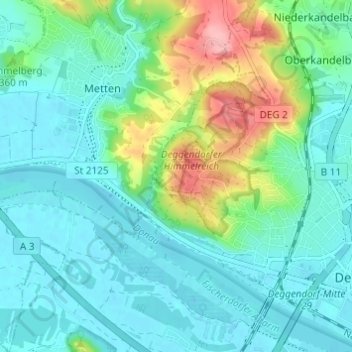
Clique no mapa para exibir a altitude.
Sobre este mapa
Nome: Mapa topográfico Schalterbach, altitude, relevo.
Altitude média: 338 m
Altitude mínima: 310 m
Altitude máxima: 428 m
Outros mapas topográficos
Clique em um mapa para visualizar sua topografia, sua altitude e seu relevo.
Großwalding
Deutschland > Bayern > Landkreis Deggendorf > Deggendorf > Kleinfilling
Großwalding, Kleinfilling, Deggendorf, Landkreis Deggendorf, Bayern, 94469, Deutschland
Altitude média: 420 m
Mietzing
Deutschland > Bayern > Landkreis Deggendorf > Deggendorf
Mietzing, Deggendorf, Landkreis Deggendorf, Bayern, 94469, Deutschland
Altitude média: 437 m
Scheidham
Deutschland > Bayern > Landkreis Deggendorf > Deggendorf > Reinprechting
Scheidham, Reinprechting, Deggendorf, Landkreis Deggendorf, Bayern, 94469, Deutschland
Altitude média: 415 m
Reinprechting
Deutschland > Bayern > Landkreis Deggendorf > Deggendorf
Reinprechting, Deggendorf, Landkreis Deggendorf, Bayern, 94469, Deutschland
Altitude média: 396 m