
Mapa topográfico El Gilf El Kebir Plateau
Mapa interativo
Clique no mapa para exibir a altitude.
Sobre este mapa
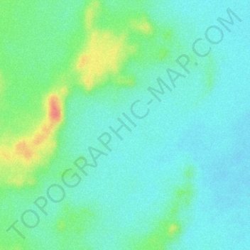
Nome: Mapa topográfico El Gilf El Kebir Plateau, altitude, relevo.
Local: El Gilf El Kebir Plateau, New Valley Governorate, Egypt (23.38046 26.08927 23.40046 26.10927)
Altitude média: 1.037 m
Altitude mínima: 1.017 m
Altitude máxima: 1.088 m
Outros mapas topográficos
Clique em um mapa para visualizar sua topografia, sua altitude e seu relevo.
Rashida
Egypt > New Valley Governorate > Rashida
Rashida, New Valley Governorate, Egypt
Altitude média: 101 m
Al-Farafra
Egypt > New Valley Governorate > Al-Farafra
Al-Farafra, New Valley Governorate, Egypt
Altitude média: 73 m
El Dakhla Oasis
Egypt > New Valley Governorate > El Dakhla Oasis
El Dakhla Oasis, New Valley Governorate, Egypt
Altitude média: 205 m
Al Izziyah
Egypt > New Valley Governorate > Al Izziyah
Al Izziyah, New Valley Governorate, Egypt
Altitude média: 68 m
Aulad Salama
Egypt > New Valley Governorate > Aulad Salama
Aulad Salama, New Valley Governorate, Egypt
Altitude média: 72 m
Dayr al Abyad
Egypt > New Valley Governorate
Dayr al Abyad, New Valley Governorate, Egypt
Altitude média: 137 m
Hawd Dandarah
Egypt > New Valley Governorate > Al Ashraf al Bahriyah
Hawd Dandarah, Al Ashraf al Bahriyah, New Valley Governorate, Egypt
Altitude média: 74 m