
Mapa topográfico Idar-Oberstein
Mapa interativo
Clique no mapa para exibir a altitude.
Sobre este mapa
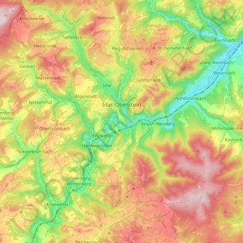
Nome: Mapa topográfico Idar-Oberstein, altitude, relevo.
Altitude média: 406 m
Altitude mínima: 210 m
Altitude máxima: 617 m
Idar-Oberstein/Göttschied Airfield lies north of the town between the constituent community of Göttschied and the municipalities of Gerach and Hintertiefenbach at an elevation of 480 m above sea level (1,575 feet). Its ICAO location indicator is EDRG. The grass landing strip's orientation is 06/24, and it is 650 m long and 50 m wide. The allowable landing weight is 2 000 kg; however, with PPR (“prior permission required”), aircraft of up to 3 700 kg may land. The airport is designed for helicopters, motor gliders, gliders, ultralights and, also with PPR, skydivers.
Outros mapas topográficos
Clique em um mapa para visualizar sua topografia, sua altitude e seu relevo.
Mittelreidenbach
Germany > Rhineland-Palatinate > Landkreis Birkenfeld
Mittelreidenbach, Herrstein-Rhaunen, Landkreis Birkenfeld, Rhineland-Palatinate, Germany
Altitude média: 340 m
Hallenbad Idar-Oberstein
Germany > Rhineland-Palatinate > Landkreis Birkenfeld > Idar-Oberstein
Hallenbad Idar-Oberstein, 213, Hauptstraße, Idar, Idar-Oberstein, Landkreis Birkenfeld, Rhineland-Palatinate, 55743, Germany
Altitude média: 343 m
Baumholder
Germany > Rhineland-Palatinate > Landkreis Birkenfeld
Baumholder, Landkreis Birkenfeld, Rhineland-Palatinate, 55774, Germany
Altitude média: 451 m
Heimbach
Germany > Rhineland-Palatinate > Landkreis Birkenfeld
Heimbach, Baumholder, Landkreis Birkenfeld, Rhineland-Palatinate, Germany
Altitude média: 412 m
Gollenberg
Germany > Rhineland-Palatinate > Landkreis Birkenfeld
Gollenberg, Birkenfeld, Landkreis Birkenfeld, Rhineland-Palatinate, Germany
Altitude média: 466 m