
Mapa topográfico Cold Fell
Clique no mapa para exibir a altitude.
Sobre este mapa
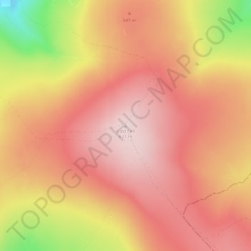
Nome: Mapa topográfico Cold Fell, altitude, relevo.
Altitude média: 517 m
Altitude mínima: 296 m
Altitude máxima: 620 m
Outros mapas topográficos
Clique em um mapa para visualizar sua topografia, sua altitude e seu relevo.
Farlam
United Kingdom > England > Cumbria > Carlisle
Farlam was originally divided into two townships, East Farlam and West Farlam, with a combined population in 1811 of 672 inhabitants and 115 houses. Hallbankgate and Kirkhouse were two hamlets located within the township of East Farlam, the former four miles south east of Brampton, and the latter, where the…
Altitude média: 167 m