
Mapa topográfico Manchester
Mapa interativo
Clique no mapa para exibir a altitude.
Manchester
According to the United States Census Bureau, the city has a total area of 35.0 square miles (90.6 km2), of which 33.1 square miles (85.7 km2) are land and 1.9 square miles (4.8 km2) are water, comprising 5.33% of the city. Manchester is drained by the Merrimack River and its tributaries the Piscataquog River and Cohas Brook. Massabesic Lake is on the eastern border. The highest point in Manchester is atop Wellington Hill, where the elevation reaches 570 feet (170 m) above sea level.
Sobre este mapa
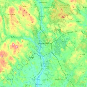
Nome: Mapa topográfico Manchester, altitude, relevo.
Altitude média: 126 m
Altitude mínima: 28 m
Altitude máxima: 400 m
Outros mapas topográficos
Clique em um mapa para visualizar sua topografia, sua altitude e seu relevo.