
Faça uma doação
Mapa topográfico Maryborough
Clique no mapa para exibir a altitude.
Faça uma doação
Maryborough
Maryborough enjoys a temperate climate with four distinct seasons and is typically dry and mild. The mean minimum January temperature 12.9 °C (55.2 °F) with the maximum a balmy 28.8 °C (83.8 °F), however temperatures above 35 °C (95 °F) are commonly recorded during the summer months. The highest temperature ever recorded was 45.4 °C (113.7 °F) on 7 February 2009. The mean minimum temperature in July is 3.4 °C (38.1 °F), with and average maximum of 12.2 °C (54.0 °F). The lowest ever recorded minimum in the city was −4.6 °C (23.7 °F) on 21 July 1982. Although the city experiences little snow due to its low elevation, frosts are common during the colder winter months.
Faça uma doação
Sobre este mapa
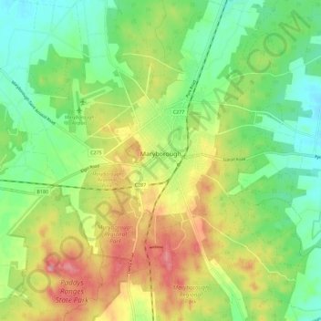
Nome: Mapa topográfico Maryborough, altitude, relevo.
Altitude média: 238 m
Altitude mínima: 194 m
Altitude máxima: 300 m
Faça uma doação