
Obrigado por apoiar este site ❤️
Faça uma doação
Faça uma doação
Mapa topográfico Magallanes
Clique no mapa para exibir a altitude.
Obrigado por apoiar este site ❤️
Faça uma doação
Faça uma doação
Magallanes
The topography of the land is mostly flat and rolling, surrounded by mountains. Swamps characterize much of the landscape that is situated at the mouth of the two major rivers in the province, the Agusan and Baug Rivers.
Obrigado por apoiar este site ❤️
Faça uma doação
Faça uma doação
Sobre este mapa
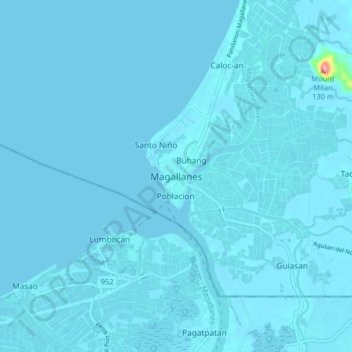
Nome: Mapa topográfico Magallanes, altitude, relevo.
Local: Magallanes, Agusan del Norte, Caraga, 8604, Philippines (8.98371 125.47851 9.06371 125.55851)
Altitude média: 3 m
Altitude mínima: 0 m
Altitude máxima: 136 m
Obrigado por apoiar este site ❤️
Faça uma doação
Faça uma doação
Outros mapas topográficos
Clique em um mapa para visualizar sua topografia, sua altitude e seu relevo.