
Faça uma doação
Mapa topográfico Bullhead City
Clique no mapa para exibir a altitude.
Faça uma doação
Bullhead City
Hardyville Pioneer Cemetery, a small cemetery, now a historic landmark at 35°7′16″N 114°35′17″W / 35.12111°N 114.58806°W / 35.12111; -114.58806, is the most significant existing remnant of Hardyville. An unofficial historical marker for the town is in the parking lot across Highway 95 from the cemetery at 35°7′16″N 114°35′17″W / 35.12111°N 114.58806°W / 35.12111; -114.58806. The Hardyville Mill ruins appeared on a USGS topographic map, at 35°7′14″N 114°34′47″W / 35.12056°N 114.57972°W / 35.12056; -114.57972.
Faça uma doação
Sobre este mapa
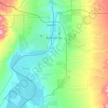
Nome: Mapa topográfico Bullhead City, altitude, relevo.
Local: Bullhead City, Mohave County, Arizona, United States (35.04049 -114.64632 35.20577 -114.45720)
Altitude média: 328 m
Altitude mínima: 145 m
Altitude máxima: 858 m
Faça uma doação
Outros mapas topográficos
Clique em um mapa para visualizar sua topografia, sua altitude e seu relevo.
Faça uma doação
Faça uma doação
Oatman
United States > Arizona > Mohave County
Oatman is a census-designated place (CDP) in the Black Mountains of Mohave County, Arizona, United States, at an elevation of 2,710 feet (830 m). In 1915, it began as a small mining camp when two prospectors struck US$10 million (equivalent to $176 million in 2024) in gold, though the vicinity had already been…
Altitude média: 894 m
Hoover Dam
United States > Arizona > Mohave County
The amount of electricity generated by Hoover Dam has been decreasing along with the falling water level in Lake Mead due to the prolonged drought since year 2000 and high demand for the Colorado River's water. By 2014 its generating capacity was downrated by 23% to 1592 MW and was providing power only during…
Altitude média: 429 m
Faça uma doação
Faça uma doação
Faça uma doação
Hoover Dam
United States > Arizona > Mohave County
The amount of electricity generated by Hoover Dam has been decreasing along with the falling water level in Lake Mead due to the prolonged drought since year 2000 and high demand for the Colorado River's water. By 2014 its generating capacity was downrated by 23% to 1592 MW and was providing power only during…
Altitude média: 429 m
Faça uma doação
Hoover Dam
United States > Arizona > Mohave County
The amount of electricity generated by Hoover Dam has been decreasing along with the falling water level in Lake Mead due to the prolonged drought in the 2010s and high demand for the Colorado River's water. Lake Mead fell to a new record low elevation of 1,071.61 feet (326.63 m) on July 1, 2016 before…
Altitude média: 429 m
Faça uma doação
Pigeon Point Lighthouse
United States > Arizona > Mohave County > Lake Havasu City
Altitude média: 155 m
Faça uma doação
Faça uma doação