
Faça uma doação
Mapa topográfico Clemson
Clique no mapa para exibir a altitude.
Faça uma doação
Sobre este mapa
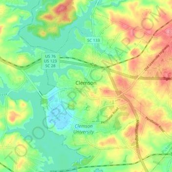
Nome: Mapa topográfico Clemson, altitude, relevo.
Altitude média: 224 m
Altitude mínima: 188 m
Altitude máxima: 276 m
Faça uma doação
Outros mapas topográficos
Clique em um mapa para visualizar sua topografia, sua altitude e seu relevo.
Dawson Park
United States > South Carolina > Pickens County > Clemson > Briarwood
Altitude média: 233 m
Faça uma doação
Faça uma doação
Sassafras Mountain
United States > South Carolina > Pickens County
The Pisgah Quadrangle topographical map, revised 1904–1905, shows the long abandoned Sassafras Gap Road to be the preferred route through to Rosman, N.C. and Brevard, N.C. at the end of the 19th century and that the existing Highway 178 was then a secondary road. This abandoned road is a short distance from…
Altitude média: 895 m
Faça uma doação
Faça uma doação
Sassafras Mountain
United States > South Carolina > Pickens County
The Pisgah Quadrangle topographical map, revised 1904–1905, shows the long abandoned Sassafras Gap Road to be the preferred route through to Rosman, N.C. and Brevard, N.C. at the end of the 19th century and that the existing Highway 178 was then a secondary road. This abandoned road is a short distance from…
Altitude média: 895 m
Faça uma doação
Clemson Heights
United States > South Carolina > Pickens County > Clemson > Clemson Heights
Altitude média: 217 m