
Mapa topográfico Sereď
Mapa interativo
Clique no mapa para exibir a altitude.
Sobre este mapa
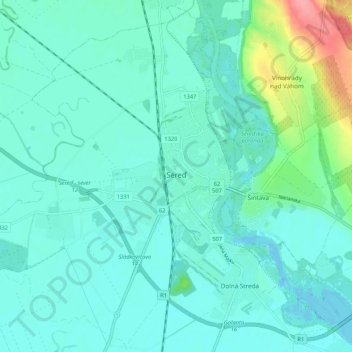
Nome: Mapa topográfico Sereď, altitude, relevo.
Altitude média: 132 m
Altitude mínima: 117 m
Altitude máxima: 204 m
Sereď lies at an altitude of 129 metres (423 ft) above sea level and covers an area of 30.454 square kilometres (11.8 sq mi). It is located in the Danubian Lowland on the Váh river, around 20 kilometres (12 mi) south-east of Trnava, 33 kilometres (21 mi) west of Nitra and around 55 kilometres (34 mi) east from Bratislava. The closest mountain ranges are the Little Carpathians to the west and Považský Inovec to the north.
Outros mapas topográficos
Clique em um mapa para visualizar sua topografia, sua altitude e seu relevo.
Sládkovičovo
Slovakia > Region of Trnava > District of Galanta
Sládkovičovo, District of Galanta, Region of Trnava, Western Slovakia, 925 21, Slovakia
Altitude média: 120 m
Šintava
Slovakia > Region of Trnava > District of Galanta
Šintava, District of Galanta, Region of Trnava, Western Slovakia, 925 51, Slovakia
Altitude média: 138 m