
Obrigado por apoiar este site ❤️
Faça uma doação
Faça uma doação
Mapa topográfico Kursk Oblast
Clique no mapa para exibir a altitude.
Obrigado por apoiar este site ❤️
Faça uma doação
Faça uma doação
Kursk Oblast
The oblast, with an average elevation of 177–225 m (581–738 ft), occupies the southern slopes of the middle-Russian plateau. The surface is hilly and intersected by ravines. The central part of Kursk oblast is more elevated than the Seym Valley to the west. The Timsko-Shchigrinsky ridge contains the highest point in the oblast at 288 m (945 ft) above the sea level. The low relief, gentle slopes, and mild winters make the area suitable for farming, and much of the forest has been cleared.
Obrigado por apoiar este site ❤️
Faça uma doação
Faça uma doação
Sobre este mapa
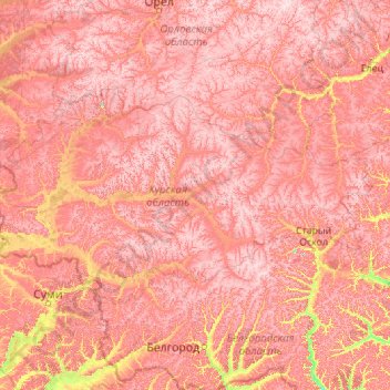
Nome: Mapa topográfico Kursk Oblast, altitude, relevo.
Local: Kursk Oblast, Central Federal District, Russia (50.90156 34.08022 52.44506 38.51927)
Altitude média: 198 m
Altitude mínima: 88 m
Altitude máxima: 284 m
Obrigado por apoiar este site ❤️
Faça uma doação
Faça uma doação