
Faça uma doação
Mapa topográfico East Lake
Clique no mapa para exibir a altitude.
Faça uma doação
Sobre este mapa
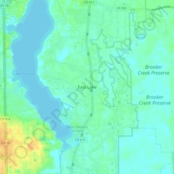
Nome: Mapa topográfico East Lake, altitude, relevo.
Local: East Lake, Pinellas County, Florida, 34685, United States (28.06837 -82.73685 28.14837 -82.65685)
Altitude média: 7 m
Altitude mínima: -2 m
Altitude máxima: 27 m
Faça uma doação
Outros mapas topográficos
Clique em um mapa para visualizar sua topografia, sua altitude e seu relevo.
Faça uma doação
Faça uma doação
Faça uma doação
Redington Shores
United States > Florida > Pinellas County
According to the United States Census Bureau, the town has a total area of 1.2 square miles (3.1 km2), of which 0.4 square miles (1.0 km2) is land and 0.8 square miles (2.1 km2) (67.50%) is water. According to Elevation Map Logs, the elevation of Redington Shores is just one meter above sea level.
Altitude média: 2 m
Faça uma doação
West and East Lealman
United States > Florida > Pinellas County
"West and East Lealman" was located at 27°49′12″N 82°41′12″W / 27.82000°N 82.68667°W / 27.82000; -82.68667 (27.820103, -82.686670). The community is adjacent to the cities of Pinellas Park, St. Petersburg, and Kenneth City. The elevation is 49 feet (15 m) above sea level.
Altitude média: 10 m
West and East Lealman
United States > Florida > Pinellas County > Saint Petersburg
"West and East Lealman" was located at 27°49′12″N 82°41′12″W / 27.82000°N 82.68667°W / 27.82000; -82.68667 (27.820103, -82.686670). The community is adjacent to the cities of Pinellas Park, St. Petersburg, and Kenneth City. The elevation is 49 feet (15 m) above sea level.
Altitude média: 12 m
Faça uma doação
Faça uma doação