
Mapa topográfico Buea
Mapa interativo
Clique no mapa para exibir a altitude.
Buea
Buea has a subtropical highland climate. Because of its location at the foot of Mount Cameroon, the climate in Buea tends to be humid, with the neighbourhoods at higher elevations enjoying cooler temperatures while the lower neighbourhoods experience a hotter climate. Extended periods of rainfall, characterized by incessant drizzle, which can last for weeks, are common during the rainy season as are damp fogs, rolling off the mountain into the town below.
Sobre este mapa
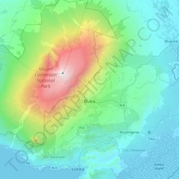
Nome: Mapa topográfico Buea, altitude, relevo.
Local: Buea, Fako, Southwest, Cameroon (4.04421 9.02681 4.31928 9.41326)
Altitude média: 791 m
Altitude mínima: -3 m
Altitude máxima: 4.014 m
Outros mapas topográficos
Clique em um mapa para visualizar sua topografia, sua altitude e seu relevo.