
Mapa topográfico Russell
Mapa interativo
Clique no mapa para exibir a altitude.
Sobre este mapa
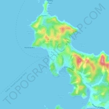
Nome: Mapa topográfico Russell, altitude, relevo.
Altitude média: 12 m
Altitude mínima: -1 m
Altitude máxima: 110 m
Outros mapas topográficos
Clique em um mapa para visualizar sua topografia, sua altitude e seu relevo.
Onewhero Bay
New Zealand > Northland > Far North District > Bay of Islands-Whangaroa Community
Onewhero Bay, Bay of Islands-Whangaroa Community, Far North District, Northland, 0204, New Zealand
Altitude média: 18 m
Kerikeri
New Zealand > Northland > Far North District > Bay of Islands-Whangaroa Community
Kerikeri, Bay of Islands-Whangaroa Community, Far North District, Northland, 0230, New Zealand
Altitude média: 76 m