
Mapa topográfico Balsthal
Mapa interativo
Clique no mapa para exibir a altitude.
Sobre este mapa
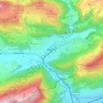
Nome: Mapa topográfico Balsthal, altitude, relevo.
Local: Balsthal, Bezirk Thal, Amtei Thal-Gäu, Solothurn, 4710, Schweiz (47.28901 7.67040 47.33697 7.74540)
Altitude média: 680 m
Altitude mínima: 453 m
Altitude máxima: 1.112 m
Outros mapas topográficos
Clique em um mapa para visualizar sua topografia, sua altitude e seu relevo.
Mümliswil
Schweiz > Solothurn > Amtei Thal-Gäu
Mümliswil, Mümliswil-Ramiswil, Bezirk Thal, Amtei Thal-Gäu, Solothurn, 4717, Schweiz
Altitude média: 744 m
Gänsbrunnen
Schweiz > Solothurn > Amtei Thal-Gäu
Gänsbrunnen, Welschenrohr-Gänsbrunnen, Bezirk Thal, Amtei Thal-Gäu, Solothurn, 4716, Schweiz
Altitude média: 961 m
Herbetswil
Schweiz > Solothurn > Amtei Thal-Gäu
Herbetswil, Bezirk Thal, Amtei Thal-Gäu, Solothurn, 4715, Schweiz
Altitude média: 850 m
Vorder Hammer
Schweiz > Solothurn > Amtei Thal-Gäu > Herbetswil
Vorder Hammer, Herbetswil, Bezirk Thal, Amtei Thal-Gäu, Solothurn, 4715, Schweiz
Altitude média: 837 m
Rinderweid
Schweiz > Solothurn > Amtei Thal-Gäu > Holderbank (SO)
Rinderweid, Holderbank (SO), Bezirk Thal, Amtei Thal-Gäu, Solothurn, 4718, Schweiz
Altitude média: 780 m
Oensingen
Schweiz > Solothurn > Amtei Thal-Gäu
Oensingen, Bezirk Gäu, Amtei Thal-Gäu, Solothurn, 4702, Schweiz
Altitude média: 558 m
Egerkingen
Schweiz > Solothurn > Amtei Thal-Gäu
Egerkingen, Bezirk Gäu, Amtei Thal-Gäu, Solothurn, 4622, Schweiz
Altitude média: 595 m