
Faça uma doação
Mapa topográfico Lago Vista
Clique no mapa para exibir a altitude.
Faça uma doação
Lago Vista
According to the United States Census Bureau, the city has a total area of 15.52 sq mi (40.2 km2) of which 14.6 sq mi (38 km2) is land and 0.6 sq mi (1.6 km2) (3.95%) is water. The peninsular city sits adjacent to, and partially within, the Balcones Canyonlands. Lago Vista has rugged terrain with elevations ranging from 774 ft (236 m) above sea level at the lake shore to 1220 ft (372 m) above sea level near Rusty Allen Airport. The area is characterized by steep limestone hills and canyons, some of the highest in Travis County.
Faça uma doação
Sobre este mapa
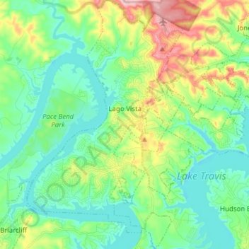
Nome: Mapa topográfico Lago Vista, altitude, relevo.
Local: Lago Vista, Travis County, Texas, United States (30.39919 -98.03744 30.50717 -97.95484)
Altitude média: 251 m
Altitude mínima: 196 m
Altitude máxima: 388 m
Faça uma doação
Outros mapas topográficos
Clique em um mapa para visualizar sua topografia, sua altitude e seu relevo.
Roy G. Guerrero Colorado River Metro Park
United States > Texas > Travis County > Austin
Altitude média: 141 m
Faça uma doação
Faça uma doação
Austin
United States > Texas > Travis County > Austin
The elevation of Austin varies from 425 feet (130 m) to approximately 1,000 feet (305 m) above sea level. Due to the fact it straddles the Balcones Fault, much of the eastern part of the city is flat, with heavy clay and loam soils, whereas the western part and western suburbs consist of rolling hills on the…
Altitude média: 203 m
Faça uma doação
Faça uma doação
Faça uma doação
Pflugerville
United States > Texas > Travis County > Pflugerville > Pflugerville
Altitude média: 219 m