
Faça uma doação
Mapa topográfico Myrtle Beach
Clique no mapa para exibir a altitude.
Faça uma doação
Myrtle Beach
Myrtle Beach features a predominantly flat topography characterized by its coastal plain setting. The area is situated just a few feet above sea level, with an average elevation of approximately 20 feet (6 meters), making it ideal for expansive sandy beaches and shallow tidal estuaries. The region is part of a continuous stretch of shoreline known as the Grand Strand, which spans about 60 miles (97 kilometers). This topography includes barrier islands and wetlands, providing a diverse habitat for various wildlife. The landscape is largely influenced by the Atlantic Ocean, with numerous inlets and swashes, like Wither's Swash, that define the coastal terrain.
Faça uma doação
Sobre este mapa
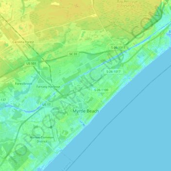
Nome: Mapa topográfico Myrtle Beach, altitude, relevo.
Local: Myrtle Beach, Horry County, South Carolina, United States (33.64738 -78.97802 33.79126 -78.78547)
Altitude média: 6 m
Altitude mínima: -5 m
Altitude máxima: 16 m
Faça uma doação
Outros mapas topográficos
Clique em um mapa para visualizar sua topografia, sua altitude e seu relevo.
Faça uma doação
Windy Hill Beach
United States > South Carolina > Horry County > North Myrtle Beach
Altitude média: 2 m
Cherry Grove Beach
United States > South Carolina > Horry County > North Myrtle Beach
Altitude média: 1 m
Ingram Beach
United States > South Carolina > Horry County > North Myrtle Beach > Ocean Drive Beach
Altitude média: 2 m
Faça uma doação
Barefoot Resort
United States > South Carolina > Horry County > North Myrtle Beach
Altitude média: 4 m
Faça uma doação
Cherry Grove Beach
United States > South Carolina > Horry County > North Myrtle Beach
Altitude média: 1 m
Faça uma doação
Seabrook Plantation
United States > South Carolina > Horry County > North Myrtle Beach
Altitude média: 3 m
Market Common District
United States > South Carolina > Horry County > Myrtle Beach
Altitude média: 5 m
Faça uma doação