
Faça uma doação
Mapa topográfico Alston
Clique no mapa para exibir a altitude.
Faça uma doação
Alston
Alston is a town in Cumbria, England, within the civil parish of Alston Moor on the River South Tyne. It shares the title of the 'highest market town in England', at about 1,000 feet (300 m) above sea level, with Buxton, Derbyshire. Despite its altitude, the town is easily accessible via the many roads which link the town to Weardale, Teesdale, and towns in Cumbria such as Penrith via Hartside Pass, as well as Tynedale. Historically part of Cumberland, Alston lies within the North Pennines, a designated Area of Outstanding Natural Beauty. Much of the town centre is a designated Conservation Area which includes several listed buildings.
Faça uma doação
Sobre este mapa
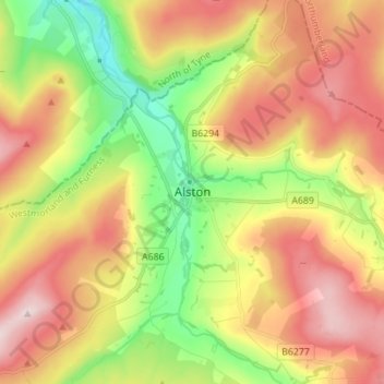
Nome: Mapa topográfico Alston, altitude, relevo.
Altitude média: 404 m
Altitude mínima: 221 m
Altitude máxima: 598 m
Faça uma doação
Outros mapas topográficos
Clique em um mapa para visualizar sua topografia, sua altitude e seu relevo.