
Faça uma doação
Mapa topográfico Kronstadt
Clique no mapa para exibir a altitude.
Faça uma doação
Kronstadt
The Kronstadt tide gauge is situated near the former Italian palace. Sea level observations in Saint Petersburg began already in 1703. On Kotlin Island, the main naval fortress of the Russian Empire began observations in 1707. This monitoring was necessary because the water level of the Finnish Gulf could change considerably in a short time, creating problems for shipping. The annual flood also required close monitoring of the water level. The Kronstadt sea-gauge with the tide gauge pavilion is the zero level of the Baltic system of highs and lows. All depths and altitudes (even the heights of spacecraft) in Russia and some other countries of the former Russian Empire are measured according to the Kronstadt sea-gauge. Yuri Gagarin, the first man in space, said in 1967 that it was "the Hub of the Universe".
Faça uma doação
Sobre este mapa
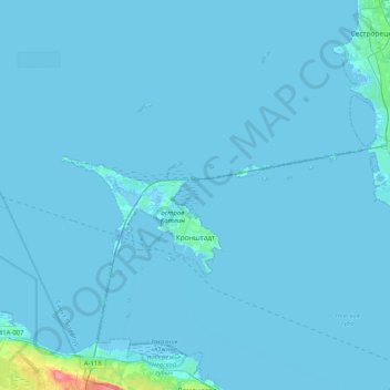
Nome: Mapa topográfico Kronstadt, altitude, relevo.
Altitude média: 2 m
Altitude mínima: -10 m
Altitude máxima: 73 m
Faça uma doação
Outros mapas topográficos
Clique em um mapa para visualizar sua topografia, sua altitude e seu relevo.
Saint Petersburg
Russia > Saint Petersburg > Saint Petersburg
The elevation of Saint Petersburg ranges from the sea level to its highest point of 175.9 m (577 ft) at the Orekhovaya Hill in the Duderhof Heights in the south. Part of the city's territory west of Liteyny Prospekt is no higher than 4 m (13 ft) above sea level, and has suffered from numerous floods. Floods in…
Altitude média: 14 m