
Mapa topográfico Agoncillo
Clique no mapa para exibir a altitude.
Sobre este mapa
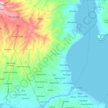
Nome: Mapa topográfico Agoncillo, altitude, relevo.
Local: Agoncillo, Batangas, Calabarzon, 4211, Philippines (13.90917 120.88950 14.01463 120.96610)
Altitude média: 102 m
Altitude mínima: 3 m
Altitude máxima: 401 m
Outros mapas topográficos
Clique em um mapa para visualizar sua topografia, sua altitude e seu relevo.
Taal Volcano
Philippines > Batangas > San Nicolas
Volcano Island sank from 1 to 3 m (3 to 10 ft) as a result of the eruption. It was also found that the southern shore of Lake Taal sank in elevation from the eruption. No evidences of lava could be discovered anywhere, nor have geologists been able to trace any visible records of a lava flow having occurred at…
Altitude média: 91 m
Batangas City
Philippines > Batangas > Batangas City > Batangas City
The city is the center of the radio listening market in Batangas, and is served by local radio stations, as well as some radio stations from Lipa and other parts of the Mega Manila area. The Roman Catholic Archdiocese of Lipa, through the Radyo Bayanihan System, hosts two local radio stations: ALFM 95.9 Radyo…
Altitude média: 108 m