
Mapa topográfico Hooker Glacier
Mapa interativo
Clique no mapa para exibir a altitude.
Sobre este mapa
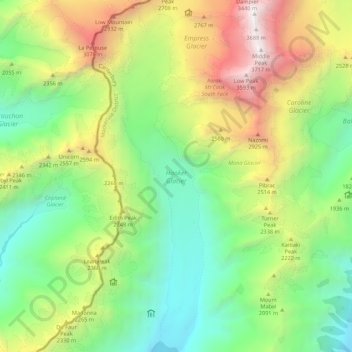
Nome: Mapa topográfico Hooker Glacier, altitude, relevo.
Local: Hooker Glacier, Westland District, West Coast, New Zealand (-43.67065 170.09221 -43.59200 170.12789)
Altitude média: 1.930 m
Altitude mínima: 889 m
Altitude máxima: 3.709 m
Outros mapas topográficos
Clique em um mapa para visualizar sua topografia, sua altitude e seu relevo.
Okuru
New Zealand > West Coast > Westland District
Okuru, Westland District, West Coast, New Zealand
Altitude média: 3 m
Gillespies Beach
New Zealand > West Coast > Westland District
Gillespies Beach, Westland District, West Coast, New Zealand
Altitude média: 14 m
Hokitika
New Zealand > West Coast > Westland District
Hokitika, Westland District, West Coast, 7810, New Zealand
Altitude média: 14 m
Waikowai Stream
New Zealand > West Coast > Westland District
Waikowai Stream, Westland District, West Coast, New Zealand
Altitude média: 13 m
Belmont
New Zealand > West Coast > Westland District
Belmont, Westland District, West Coast, New Zealand
Altitude média: 1.623 m
Haast
New Zealand > West Coast > Westland District
Haast, Westland District, West Coast, New Zealand
Altitude média: 15 m
Fox Glacier
New Zealand > West Coast > Westland District
Fox Glacier, Westland District, West Coast, New Zealand
Altitude média: 1.848 m
Franz Josef
New Zealand > West Coast > Westland District
Franz Josef, Westland District, West Coast, 7856, New Zealand
Altitude média: 277 m
Mount Tasman
New Zealand > West Coast > Westland District
Mount Tasman, Westland District, West Coast, New Zealand
Altitude média: 2.798 m