
Mapa topográfico Crawford Notch State Park
Mapa interativo
Clique no mapa para exibir a altitude.
Sobre este mapa
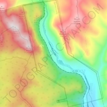
Nome: Mapa topográfico Crawford Notch State Park, altitude, relevo.
Altitude média: 796 m
Altitude mínima: 331 m
Altitude máxima: 1.299 m
Outros mapas topográficos
Clique em um mapa para visualizar sua topografia, sua altitude e seu relevo.
Sawyers River
United States > New Hampshire > Carroll County > Hart's Location
Sawyers River, Hart's Location, Carroll County, New Hampshire, United States
Altitude média: 457 m
Mount Willard
United States > New Hampshire > Carroll County > Hart's Location
Mount Willard, Hart's Location, Carroll County, New Hampshire, United States
Altitude média: 775 m