
Mapa topográfico Kowloon City District
Mapa interativo
Clique no mapa para exibir a altitude.
Sobre este mapa
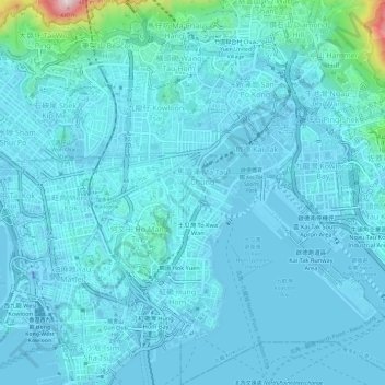
Nome: Mapa topográfico Kowloon City District, altitude, relevo.
Local: Kowloon City District, Kowloon, Hong Kong, China (22.29411 114.17273 22.34933 114.21938)
Altitude média: 37 m
Altitude mínima: -31 m
Altitude máxima: 438 m
Outros mapas topográficos
Clique em um mapa para visualizar sua topografia, sua altitude e seu relevo.
Kwun Tong District
Kwun Tong District, Kowloon, Hong Kong, China
Altitude média: 61 m
Kowloon Walled City Park
Kowloon Walled City Park, Kau Pui Shek, Kowloon City, Kowloon City District, Kowloon, Hong Kong, China
Altitude média: 28 m
Jordan Valley
Jordan Valley, Shun On Road, Choi Wan, Jordan Valley, Kowloon, Kwun Tong District, Hong Kong, China
Altitude média: 107 m