
Faça uma doação
Mapa topográfico Largo
Clique no mapa para exibir a altitude.
Faça uma doação
Largo
In 2010, Largo's total area was 18.6 square miles (48.1 km2), of which 17.6 square miles (45.6 km2) was land and 0.97 square miles (2.5 km2), or 5.22%, was water. As of 2004, there were 651 acres (2.6 km2) of park lands. The city's lowest elevation is sea level. At its highest, the city's elevation is about 69 feet (21 m). Largo is dotted with a number of lakes, the largest of which is Taylor Lake at 53 acres (210,000 m2). Allen's Creek drains northeast Largo, flowing into Tampa Bay. McKay Creek flows through southwest Largo into the Intracoastal Waterway. The McKay Creek basin is prone to flooding.
Faça uma doação
Sobre este mapa
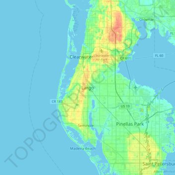
Nome: Mapa topográfico Largo, altitude, relevo.
Local: Largo, Pinellas County, Florida, 33770-1815, United States (27.74947 -82.94732 28.06947 -82.62732)
Altitude média: 5 m
Altitude mínima: -2 m
Altitude máxima: 35 m
Faça uma doação
Outros mapas topográficos
Clique em um mapa para visualizar sua topografia, sua altitude e seu relevo.