
Mapa topográfico Qalb Lawzah
Mapa interativo
Clique no mapa para exibir a altitude.
Qalb Lawzah
Qalb Loze lies at an elevation of 670 meters in the Idlib Governorate on the A'la Mountain (Jabal Summaq) plateau, a remote hilly region of western central part of the northern Syrian limestone massif, a few kilometers from the Turkish border. The place is near Barisha and is accessible from the main Aleppo-Antakya road by a secondary road that heads northeast. Nearby localities include Qurqania to the south, Kafr Dariyan to the east and Kafr Takharim to the west.
Sobre este mapa
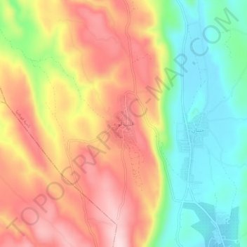
Nome: Mapa topográfico Qalb Lawzah, altitude, relevo.
Altitude média: 590 m
Altitude mínima: 450 m
Altitude máxima: 729 m