
Faça uma doação
Mapa topográfico Kursk Oblast
Clique no mapa para exibir a altitude.
Faça uma doação
Kursk Oblast
The oblast, with an average elevation is 177–225 meters (580–738 ft), occupies the southern slopes of the middle-Russian plateau. The surface is hilly and intersected by ravines. The central part of Kursk oblast is more elevated than the Seym Valley to the west. The Timsko-Shchigrinsky ridge contains the highest point in the oblast at 288 meters (945 ft) above the sea level. The low relief, gentle slopes, and mild winters make the area suitable for farming, and much of the forest has been cleared.
Faça uma doação
Sobre este mapa
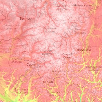
Nome: Mapa topográfico Kursk Oblast, altitude, relevo.
Local: Kursk Oblast, Central Federal District, Russia (49.09685 33.92527 54.21685 39.04527)
Altitude média: 173 m
Altitude mínima: 54 m
Altitude máxima: 292 m
Faça uma doação
Outros mapas topográficos
Clique em um mapa para visualizar sua topografia, sua altitude e seu relevo.
Faça uma doação
Kursk
Kursk, located in the Central Federal District of Russia, has a gently rolling topography typical of the Central Russian Upland. Its elevation ranges between 486 and 883 feet (148 to 269 meters) above sea level, with the city itself averaging around 653 feet (199 meters). The terrain is predominantly…
Altitude média: 192 m
Faça uma doação
Faça uma doação
Faça uma doação
Faça uma doação
Faça uma doação
Faça uma doação
Faça uma doação
Faça uma doação
Faça uma doação
Faça uma doação
Faça uma doação
Faça uma doação
Faça uma doação