
Obrigado por apoiar este site ❤️
Faça uma doação
Faça uma doação
Mapa topográfico Moraine Lake
Clique no mapa para exibir a altitude.
Obrigado por apoiar este site ❤️
Faça uma doação
Faça uma doação
Moraine Lake
Moraine Lake is a snow and glacially fed lake in Banff National Park, 14 kilometres (8.7 mi) outside the village of Lake Louise, Alberta, Canada. It is situated in the Valley of the Ten Peaks, at an elevation of approximately 1,884 metres (6,181 ft). The lake has a surface area of 50 hectares (120 acres).
Obrigado por apoiar este site ❤️
Faça uma doação
Faça uma doação
Sobre este mapa
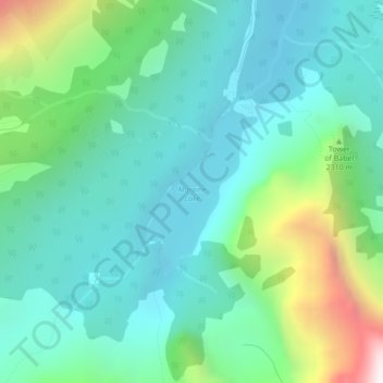
Nome: Mapa topográfico Moraine Lake, altitude, relevo.
Local: Moraine Lake, Improvement District No. 9, Alberta, Canada (51.31569 -116.19126 51.32768 -116.17854)
Altitude média: 2.101 m
Altitude mínima: 1.825 m
Altitude máxima: 2.979 m
Obrigado por apoiar este site ❤️
Faça uma doação
Faça uma doação
Outros mapas topográficos
Clique em um mapa para visualizar sua topografia, sua altitude e seu relevo.