
Obrigado por apoiar este site ❤️
Faça uma doação
Faça uma doação
Mapa topográfico Coxhoe
Clique no mapa para exibir a altitude.
Obrigado por apoiar este site ❤️
Faça uma doação
Faça uma doação
Sobre este mapa
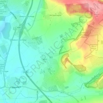
Nome: Mapa topográfico Coxhoe, altitude, relevo.
Local: Coxhoe, County Durham, North East, England, United Kingdom (54.70684 -1.52906 54.73795 -1.47162)
Altitude média: 111 m
Altitude mínima: 73 m
Altitude máxima: 188 m
Obrigado por apoiar este site ❤️
Faça uma doação
Faça uma doação
Outros mapas topográficos
Clique em um mapa para visualizar sua topografia, sua altitude e seu relevo.
Obrigado por apoiar este site ❤️
Faça uma doação
Faça uma doação
West Rainton
United Kingdom > England > County Durham
The following is from History, Topography and Directory of Durham, Whellan, London, 1894; "The village of West Rainton is about four miles north-east of Durham, and formerly contained an ancient chapel with chantry dedicated to the Virgin Mary; some of the old stones may be seen in the different buildings in…
Altitude média: 79 m