
Mapa topográfico Wernigerode
Mapa interativo
Clique no mapa para exibir a altitude.
Sobre este mapa
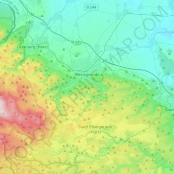
Nome: Mapa topográfico Wernigerode, altitude, relevo.
Local: Wernigerode, Landkreis Harz, Sachsen-Anhalt, Deutschland (51.75220 10.57385 51.88704 10.90049)
Altitude média: 381 m
Altitude mínima: 139 m
Altitude máxima: 1.062 m
Die West-Ost-Ausdehnung des Stadtgebiets mitsamt den eingemeindeten Ortsteilen beträgt 22 km, die Nord-Süd-Ausdehnung 14 km. Die Kernstadt liegt auf etwa 257 m ü. NHN. Der höchste Punkt des Stadtgebiets ist mit 1141,2 m der Gipfel des Brocken, der tiefste liegt auf etwa 215 m Höhe.
Outros mapas topográficos
Clique em um mapa para visualizar sua topografia, sua altitude e seu relevo.
Quedlinburg
Deutschland > Sachsen-Anhalt > Landkreis Harz
Quedlinburg, Landkreis Harz, Sachsen-Anhalt, Deutschland
Altitude média: 232 m
Brocken
Deutschland > Sachsen-Anhalt > Landkreis Harz > Wernigerode
Brocken, Wernigerode, Landkreis Harz, Sachsen-Anhalt, Deutschland
Altitude média: 963 m