
Mapa topográfico Shiyan
Mapa interativo
Clique no mapa para exibir a altitude.
Shiyan
The far northern and southern reaches of Shiyan are the highest in elevation, while the geographic center of the city has a relatively low elevation. The highest point in Shiyan is Congping in Zhuxi County, at 2,740.2 metres (8,990 ft) above sea level, while the lowest point, Panjiayan in Danjiangkou, is 87 metres (285 ft) above sea level. Hills and mountains in Shiyan generally have steep inclines, and many of its rivers have steep drops and rapid water flows. Major rivers in Shiyan include the Du River and the Han River. The Wudang Mountains run east-west through Shiyan. The peak commonly referred to as "Wudang Mountain", or in Mandarin Wudangshan, is one of the most important cultural centres of the Taoist faith. The surrounding areas are dotted with up to 200 Taoist monastic temples and religious sites.
Sobre este mapa
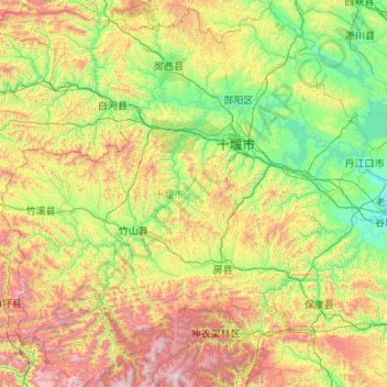
Nome: Mapa topográfico Shiyan, altitude, relevo.
Local: Shiyan, Hubei, China (31.50762 109.43630 33.27277 111.57990)
Altitude média: 782 m
Altitude mínima: 78 m
Altitude máxima: 2.898 m
Outros mapas topográficos
Clique em um mapa para visualizar sua topografia, sua altitude e seu relevo.
Mount Wudang
China > Hubei > Danjiangkou City
Modern maps show the elevation of the highest of the peaks in the Wudang Shan "proper" as 1612 meters; however, the entire Wudangshan range has somewhat higher elevations elsewhere.
Altitude média: 1.172 m
Mount Wudang
China > Hubei > Danjiangkou City
Modern maps show the elevation of the highest of the peaks in the Wudang Shan "proper" as 1612 meters; however, the entire Wudangshan range has somewhat higher elevations elsewhere.
Altitude média: 1.172 m
Yuxi
Tempered by the low latitude and moderate elevation, Yuxi has a mild subtropical highland climate (Köppen Cwb), with short, mild, dry winters, and warm, rainy summers. Frost may occur in winter but the days still generally warm up to around 17 °C (63 °F). During summer, a majority of the days features some…
Altitude média: 66 m