
Faça uma doação
Mapa topográfico Mount Silex
Clique no mapa para exibir a altitude.
Faça uma doação
Sobre este mapa
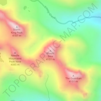
Nome: Mapa topográfico Mount Silex, altitude, relevo.
Local: Mount Silex, San Juan County, Colorado, United States (37.67023 -107.54816 37.67033 -107.54806)
Altitude média: 3.678 m
Altitude mínima: 3.260 m
Altitude máxima: 4.182 m
Faça uma doação
Outros mapas topográficos
Clique em um mapa para visualizar sua topografia, sua altitude e seu relevo.
Silverton
United States > Colorado > San Juan County
According to the United States Census Bureau, the town has a total area of 0.8 square miles (2.1 km2), all of it land. Silverton is one of the highest towns in the United States, at 9,318 feet (2,840 m) above sea level. The town is located in San Juan County, the highest county in the United States, with a…
Altitude média: 2.991 m