
Faça uma doação
Mapa topográfico El Paso
Clique no mapa para exibir a altitude.
Faça uma doação
El Paso
El Paso is characterized by a diverse and striking topography shaped by its desert environment and mountainous landscapes. The city is situated at an average elevation of approximately 3,700 feet above sea level, surrounded by the rugged Franklin Mountains to the west, where peaks exceed 7,000 feet. This range is part of the southern Rocky Mountains and features steep slopes, rocky outcrops, and deep canyons, providing a dramatic backdrop to the urban landscape. The area is predominantly within the Chihuahuan Desert, contributing to its arid climate and sparse vegetation, which includes cacti and other hardy plants. Additionally, the Rio Grande flows along the city's southern boundary, creating a fertile valley that contrasts sharply with the surrounding desert terrain. This combination of mountains, desert, and river valleys not only defines the physical landscape of El Paso but also influences local climate patterns and biodiversity, making it a unique geographic region within Texas.
Faça uma doação
Sobre este mapa
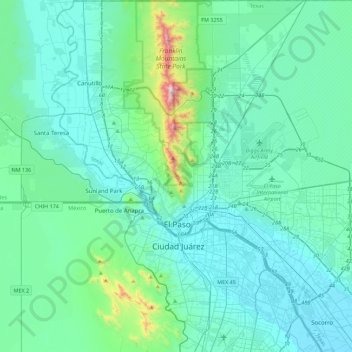
Nome: Mapa topográfico El Paso, altitude, relevo.
Local: El Paso, El Paso County, Texas, United States (31.62222 -106.63578 32.00148 -106.19915)
Altitude média: 1.237 m
Altitude mínima: 1.111 m
Altitude máxima: 2.160 m
Faça uma doação
Outros mapas topográficos
Clique em um mapa para visualizar sua topografia, sua altitude e seu relevo.
Faça uma doação
Colonia del Rio Number 1
United States > Texas > El Paso County > San Elizario
Altitude média: 1.108 m
Faça uma doação
Faça uma doação