
Faça uma doação
Mapa topográfico Winnipeg
Clique no mapa para exibir a altitude.
Faça uma doação
Winnipeg
Winnipeg lies at the bottom of the Red River Valley, a flood plain with an extremely flat topography. It is on the eastern edge of the Canadian Prairies in Western Canada and is known as the "Gateway to the West". Winnipeg is bordered by tallgrass prairie to the west and south and the aspen parkland to the northeast, although most of the native prairie grasses have been removed for agriculture and urbanization. It is relatively close to many large Canadian Shield lakes and parks, as well as Lake Winnipeg (the Earth's 11th largest freshwater lake). Winnipeg has North America's largest extant mature urban elm forest. The city has an area of 464.08 km2 (179.18 sq mi).
Faça uma doação
Sobre este mapa
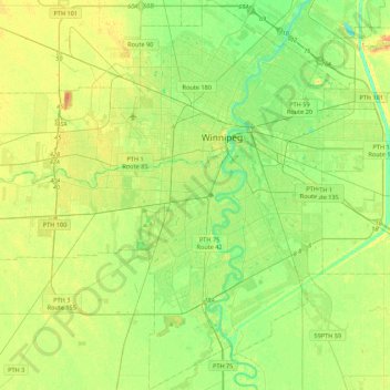
Nome: Mapa topográfico Winnipeg, altitude, relevo.
Local: Winnipeg, Manitoba, Canada (49.71355 -97.34915 49.99401 -96.95653)
Altitude média: 236 m
Altitude mínima: 222 m
Altitude máxima: 261 m
Faça uma doação
Outros mapas topográficos
Clique em um mapa para visualizar sua topografia, sua altitude e seu relevo.
Faça uma doação
Winnipeg
Canada > Manitoba > Winnipeg > Winnipeg
Winnipeg lies at the bottom of the Red River Valley, a flood plain with an extremely flat topography. It is on the eastern edge of the Canadian Prairies in Western Canada and is known as the "Gateway to the West". Winnipeg is bordered by tallgrass prairie to the west and south and the aspen parkland to the…
Altitude média: 236 m
Riding Mountain National Park
The climate in the Riding Mountain region is similar to that of other regions of southwestern Manitoba. Under the Köppen classification it has a continental climate. It includes grasslands, upland boreal and eastern deciduous forest ecosystems. The park has hot summers and cold winters, with annual rainfall…
Altitude média: 488 m
Faça uma doação
Faça uma doação
Faça uma doação
Faça uma doação
Faça uma doação
Faça uma doação
Faça uma doação
Faça uma doação
Faça uma doação
Faça uma doação
Faça uma doação
Faça uma doação
Clear Lake
Canada > Manitoba > Division No. 18 > Rural Municipality of Grahamdale
Altitude média: 251 m
Faça uma doação
Faça uma doação
Rowland Lake
Canada > Manitoba > Division No. 15 > Rural Municipality of Rosedale
Altitude média: 692 m
Faça uma doação
Faça uma doação
Bakers Narrows
Canada > Manitoba > Division No. 21 > Unorganized Division No. 21
Altitude média: 297 m
Elphinstone
Canada > Manitoba > Division No. 15 > Rural Municipality of Yellowhead
Altitude média: 583 m
Faça uma doação
Faça uma doação
Faça uma doação
Faça uma doação
Faça uma doação
Faça uma doação
Wasagaming
Canada > Manitoba > Unorganized Division No. 17
Wasagaming has a subarctic climate (Dfc) due to its northerly location and high elevation. Winters are extremely cold and relatively dry with little chance of a mid-winter thaw. The average annual temperature is 0.7 °C (33.3 °F). Annual precipitation is 488 mm (19.2 in).
Altitude média: 630 m
Red River Floodway
Canada > Manitoba > Rural Municipality of Springfield > Winnipeg
Altitude média: 236 m
Faça uma doação
Faça uma doação