
Faça uma doação
Mapa topográfico Sydnorsville
Clique no mapa para exibir a altitude.
Faça uma doação
Sobre este mapa
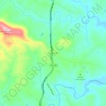
Nome: Mapa topográfico Sydnorsville, altitude, relevo.
Local: Sydnorsville, Franklin County, Virginia, United States (36.87208 -79.88531 36.91208 -79.84531)
Altitude média: 332 m
Altitude mínima: 272 m
Altitude máxima: 495 m
Faça uma doação
Outros mapas topográficos
Clique em um mapa para visualizar sua topografia, sua altitude e seu relevo.
Faça uma doação
Boones Mill
United States > Virginia > Franklin County
According to the United States Census Bureau, the town has a total area of 0.73 square miles (1.9 km2), all of it land. The town is in the valley of Maggodee Creek, a southeast-flowing tributary of the Blackwater River, part of the Roanoke River watershed. Murray Knob, elevation 2,286 feet (697 m), rises 2…
Altitude média: 390 m
Faça uma doação