
Mapa topográfico Wyandanch
Mapa interativo
Clique no mapa para exibir a altitude.
Sobre este mapa
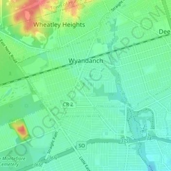
Nome: Mapa topográfico Wyandanch, altitude, relevo.
Altitude média: 21 m
Altitude mínima: 10 m
Altitude máxima: 58 m
The community was formerly known as Half Way Hollow Hills, West Deer Park (beginning in 1875), and Wyandance (in 1888). Topographically, Wyandanch's nutrient-poor loam and sandy soils are part of the outwash plain which was formed as the last glacier melted about 10,000 BCE. The outwash plain slopes gently towards Belmont Lake State Park from the Half Way Hollow Hills terminal moraine and from Little East Neck Road.
Outros mapas topográficos
Clique em um mapa para visualizar sua topografia, sua altitude e seu relevo.
North Amityville
United States > New York > Suffolk County > Town of Babylon
North Amityville, Town of Babylon, Suffolk County, New York, United States
Altitude média: 15 m
Copiague
United States > New York > Suffolk County > Town of Babylon
Copiague, Town of Babylon, Suffolk County, New York, United States
Altitude média: 6 m
North Lindenhurst
United States > New York > Suffolk County > Town of Babylon
North Lindenhurst, Town of Babylon, Suffolk County, New York, United States
Altitude média: 14 m
Village of Lindenhurst
United States > New York > Suffolk County > Town of Babylon
Village of Lindenhurst, Town of Babylon, Suffolk County, New York, 11757, United States
Altitude média: 7 m
North Babylon
United States > New York > Suffolk County > Town of Babylon
North Babylon, Town of Babylon, Suffolk County, New York, 11703, United States
Altitude média: 13 m
Deer Park
United States > New York > Suffolk County > Town of Babylon
Deer Park, Town of Babylon, Suffolk County, New York, 11729, United States
Altitude média: 25 m
Village of Amityville
United States > New York > Suffolk County > Town of Babylon
Village of Amityville, Town of Babylon, Suffolk County, New York, United States
Altitude média: 6 m