
Faça uma doação
Mapa topográfico Bountiful
Clique no mapa para exibir a altitude.
Faça uma doação
Sobre este mapa
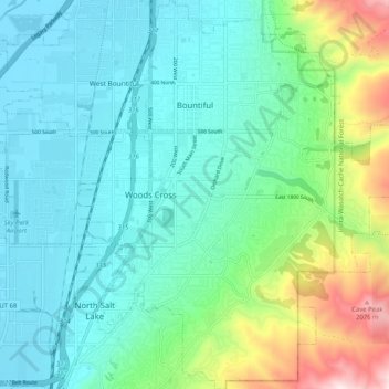
Nome: Mapa topográfico Bountiful, altitude, relevo.
Local: Bountiful, Davis County, Utah, 84010, United States (40.83291 -111.90212 40.91028 -111.81538)
Altitude média: 1.477 m
Altitude mínima: 1.280 m
Altitude máxima: 2.160 m
Faça uma doação
Outros mapas topográficos
Clique em um mapa para visualizar sua topografia, sua altitude e seu relevo.
Antelope Island
United States > Utah > Davis County
The island is accessible via a 7-mile causeway from Syracuse in Davis County. Access from Interstate 15 is via exit 332, then west along Antelope Drive (SR-108). The island's shore (all but west side of the island) is mostly flat with beaches and plains to the base of the mountains on the island. These steep…
Altitude média: 1.306 m
Faça uma doação
Faça uma doação
Mount Lebannon Acres
United States > Utah > Davis County > Centerville > Rosedale
Altitude média: 1.464 m