Mapa topográfico Zwiesel
Clique no mapa para exibir a altitude.
Zwiesel
Zwiesel has an humid continental climate (Köppen: Dfb; Trewartha: Dclo). The Zwiesel weather station is located at an altitude of 615 m (2,018 ft). The temperature is significantly lower than in most parts of Germany by several degrees. At the same time, the average annual precipitation exceeds 1,000 mm (39 in), which is relatively rare in Germany.
Sobre este mapa
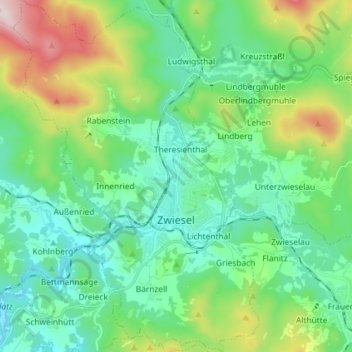
Nome: Mapa topográfico Zwiesel, altitude, relevo.
Local: Zwiesel, Landkreis Regen, Bavaria, Germany (48.97739 13.16353 49.07248 13.26513)
Altitude média: 680 m
Altitude mínima: 525 m
Altitude máxima: 1.141 m
Outros mapas topográficos
Clique em um mapa para visualizar sua topografia, sua altitude e seu relevo.

Ludwigsthal
Germany > Bavaria > Landkreis Regen > Lindberg
The chapelry of Ludwigsthal was established in 1894; this was followed in 1912 by its elevation to a parish.
Altitude média: 662 m
Großer Arber
Germany > Bavaria > Landkreis Regen > Bayerisch Eisenstein
The Großer Arber (German pronunciation); Czech: Velký Javor, "Great Maple") or Great Arber, is the highest peak of the Bavarian/Bohemian Forest mountain range and in Lower Bavaria, with an elevation of 1,455.5 metres (4,775 ft). As a result, it is known in the Lower Bavarian county of Regen and the Upper…
Altitude média: 1.141 m