
Faça uma doação
Mapa topográfico Sumilao
Clique no mapa para exibir a altitude.
Faça uma doação
Sobre este mapa
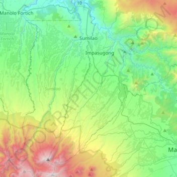
Nome: Mapa topográfico Sumilao, altitude, relevo.
Local: Sumilao, Bukidnon, Northern Mindanao, Philippines (8.11239 124.85496 8.38789 124.99121)
Altitude média: 1.001 m
Altitude mínima: 232 m
Altitude máxima: 2.892 m
Faça uma doação
Outros mapas topográficos
Clique em um mapa para visualizar sua topografia, sua altitude e seu relevo.
Malaybalay
The average elevation of the city is 622 metres (2,041 ft) above sea level. About 60% of the city's area has above 30% slope, characterized by steep hills, mountains, and cliff-like stream side. About 25% are level, gently sloping, and undulating. The rest are rolling and hilly.
Altitude média: 822 m
Faça uma doação
Faça uma doação
Lake Apo
Philippines > Bukidnon > Valencia
Lake Apo is a crater lake in Barangay Guinoyoran in the city of Valencia in Bukidnon province in the Philippines. It is located in a hilly area about 640 metres (2,100 ft) in elevation, about 11 kilometres (6.8 mi) WSW of the city poblacion (town center). Lake Apo was awarded the cleanest inland body of water…
Altitude média: 643 m
Faça uma doação
Faça uma doação
Valencia
Philippines > Bukidnon > Valencia
The city's topography is characterized as flat to undulating hills with extensive plateaus and mountainous areas and cliffs on both eastern and western portions bounding the municipality of San Fernando on the east and the municipality of Talakag on the west. Its highest point is Mount Kalatungan in the…
Altitude média: 566 m
Faça uma doação
Faça uma doação
Faça uma doação
Faça uma doação