
Mapa topográfico Schwindkirchen
Mapa interativo
Clique no mapa para exibir a altitude.
Sobre este mapa
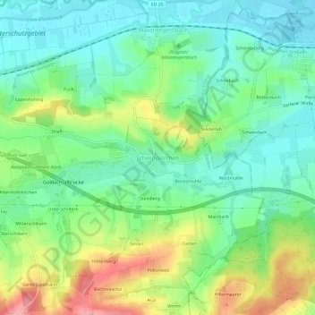
Nome: Mapa topográfico Schwindkirchen, altitude, relevo.
Altitude média: 468 m
Altitude mínima: 427 m
Altitude máxima: 548 m
Outros mapas topográficos
Clique em um mapa para visualizar sua topografia, sua altitude e seu relevo.
Wolfeck
Deutschland > Bayern > Landkreis Erding > Dorfen
Wolfeck, Dorfen, Landkreis Erding, Bayern, 84419, Deutschland
Altitude média: 457 m
Eibach
Deutschland > Bayern > Landkreis Erding > Dorfen
Eibach, Dorfen, Landkreis Erding, Bayern, 84405, Deutschland
Altitude média: 481 m
Lappach
Deutschland > Bayern > Landkreis Erding > Dorfen
Lappach, Dorfen, Landkreis Erding, Bayern, 84405, Deutschland
Altitude média: 478 m