
Mapa topográfico Tambunan
Mapa interativo
Clique no mapa para exibir a altitude.
Tambunan
Tambunan (Malay: Pekan Tambunan) is the capital of the Tambunan District in the Interior Division of Sabah, Malaysia. Its population was estimated to be around 35,667 in 2010. It is located 80 kilometres east of the state capital, Kota Kinabalu (to which is connected by the Kota Kinabalu-Tambunan-Keningau Highway), 48 kilometres south of Ranau and 48 kilometres north of Keningau. At an average altitude of 750 metres, this valley town, which is part of the Crocker Range, experiences a mild tropical climate all year long. The valley is peppered with terraced paddy fields and 70 villages. The dense forests of bamboo around Tambunan town are a legacy of the British colonial period, during which an edict stated that 20 bamboo sprouts had to be planted for every bamboo cut.
Sobre este mapa
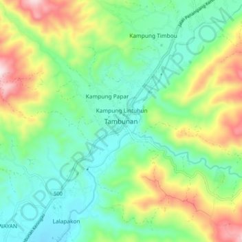
Nome: Mapa topográfico Tambunan, altitude, relevo.
Local: Tambunan, Interior Division, Sabah, 89650, Malaysia (5.62880 116.32554 5.70880 116.40554)
Altitude média: 697 m
Altitude mínima: 504 m
Altitude máxima: 1.108 m