Mapa topográfico County Limerick
Clique no mapa para exibir a altitude.
County Limerick
One possible meaning for the county's name in Irish Luimneach is "the flat area"; this description is accurate as the land consists mostly of a fertile limestone plain. Moreover, the county is ringed by mountains: the Slieve Felims to the northeast, the Galtees to the southeast, the Ballyhoura Mountains to the south, and the Mullaghareirk Mountains to the southwest and west. The highest point in the county is located in its southeast corner at Galtymore (919 m), which separates Limerick from County Tipperary. Limerick shares the 3rd-highest county peak in Ireland with Tipperary. The county is not simply a plain, its topography consists of hills and ridges. The eastern part of the county is part of the Golden Vale, which is well known for dairy produce and consists of rolling low hills. This gives way to very flat land around the centre of the county, with the exception being Knockfierna at 288 m high. Towards the west, the Mullaghareirk Mountains (Mullach an Radhairc in Irish, roughly meaning "mountains of the view") push across the county offering extensive views east over the county and west into County Kerry.
Sobre este mapa
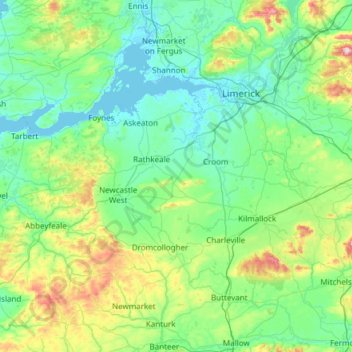
Nome: Mapa topográfico County Limerick, altitude, relevo.
Local: County Limerick, Munster, Ireland (52.28020 -9.36543 52.69629 -8.15637)
Altitude média: 107 m
Altitude mínima: -2 m
Altitude máxima: 688 m
Outros mapas topográficos
Clique em um mapa para visualizar sua topografia, sua altitude e seu relevo.















Greystones
Greystones is located south of the site of an ancient castle of the Barony of Rathdown. There was a hamlet which, like Rathdown Castle, was known as Rathdown, and which appeared on a 1712 map. This site occupied an area now known as the Grove, north of Greystones harbour, but only the ruins of a chapel, St.…
Altitude média: 49 m


Galtymore
Ireland > County Limerick > The Municipal District of Cappamore — Kilmallock
Galtymore or Galteemore (Irish: Cnoc Mór na nGaibhlte, meaning 'big hill of the Galtees') is a mountain in the province of Munster, Ireland. At 917.9 metres (3,011 ft 6 in), it is one of Ireland's highest mountains, being the 12th-highest on the Arderin list, and 14th-highest on the Vandeleur-Lynam list.…
Altitude média: 594 m


Bruff
Ireland > County Limerick > The Municipal District of Cappamore — Kilmallock
Altitude média: 68 m



Swords
Ireland > County Dublin > Swords
The medieval town developed in a linear pattern along Main Street, in a roughly north-south direction. Swords has one of the best examples of this settlement pattern in the Dublin region. The round tower, 26m in height, is also an indicator of early Christian settlement. The Irish high king Brian Boru is said…
Altitude média: 28 m

Limerick
Limerick's climate is classified as temperate oceanic (Köppen Cfb). Met Éireann maintains a climatological weather station at Shannon Airport, 20 kilometres west of the city in County Clare. Shannon Airport records an average of 977 millimetres of precipitation annually, most of which is rain. Limerick has a…
Altitude média: 54 m