
Faça uma doação
Mapa topográfico Bribie Island
Clique no mapa para exibir a altitude.
Faça uma doação
Bribie Island
Bribie Island, located in Queensland, Australia, is a low-lying, elongated landmass stretching approximately 34 kilometers (21 miles) in length and up to 8 kilometers (5 miles) at its widest point. Composed predominantly of coastal sand plains, the island features two large, low-lying dunes extending northwestward. To the east, the island is bordered by the Pacific Ocean, while to the west, it is separated from the mainland by the Pumicestone Passage, a narrow waterway that has experienced significant morphological changes due to natural events. The island's terrain is characterized by eucalypt forests, banksias, and heathlands, with extensive mangrove forests along the western shoreline.
Faça uma doação
Sobre este mapa
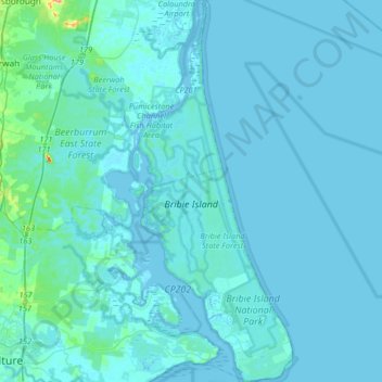
Nome: Mapa topográfico Bribie Island, altitude, relevo.
Altitude média: 6 m
Altitude mínima: -2 m
Altitude máxima: 124 m
Faça uma doação
Outros mapas topográficos
Clique em um mapa para visualizar sua topografia, sua altitude e seu relevo.
Faça uma doação
Faça uma doação
Faça uma doação
Faça uma doação
Torres Strait
Several clusters of islands lie in the Strait, collectively called the Torres Strait Islands. There are at least 274 of these islands, of which 17 have present-day permanent settlements. These islands have a variety of topographies, ecosystems and formation history. Several of those closest to the New Guinea…
Altitude média: 0 m
Faça uma doação
Faça uma doação
Faça uma doação
Faça uma doação
Faça uma doação
Faça uma doação
Faça uma doação
Faça uma doação
Faça uma doação
Faça uma doação
Faça uma doação
Faça uma doação
Faça uma doação
Faça uma doação