Geolocalizar

Mapa topográfico Romilly-sur-Aigre

Mapa interativo

Clique no mapa para exibir a altitude.

Sobre este mapa

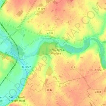
Nome: Mapa topográfico Romilly-sur-Aigre, altitude, relevo.

Local: Romilly-sur-Aigre, Cloyes-les-Trois-Rivières, Châteaudun, Eure-et-Loir, Centre-Val de Loire, France métropolitaine, 28220, France (47.96148 1.24796 47.99732 1.32091)

Altitude média: 118 m

Altitude mínima: 90 m

Altitude máxima: 137 m

Outros mapas topográficos

Clique em um mapa para visualizar sua topografia, sua altitude e seu relevo.

Autheuil

France > Centre-Val de Loire > Eure-et-Loir > Cloyes-les-Trois-Rivières

Autheuil, Cloyes-les-Trois-Rivières, Châteaudun, Eure-et-Loir, Centre-Val de Loire, France métropolitaine, 28220, France

Altitude média: 123 m

Saint-Hilaire-sur-Yerre

France > Centre-Val de Loire > Eure-et-Loir > Cloyes-les-Trois-Rivières

Saint-Hilaire-sur-Yerre, Cloyes-les-Trois-Rivières, Châteaudun, Eure-et-Loir, Centre-Val de Loire, France métropolitaine, 28220, France

Altitude média: 135 m

Charray

France > Centre-Val de Loire > Eure-et-Loir > Cloyes-les-Trois-Rivières

Charray, Cloyes-les-Trois-Rivières, Châteaudun, Eure-et-Loir, Centre-Val de Loire, France métropolitaine, 28220, France

Altitude média: 124 m

Cloyes-sur-le-Loir

France > Centre-Val de Loire > Eure-et-Loir > Cloyes-les-Trois-Rivières

Cloyes-sur-le-Loir, Cloyes-les-Trois-Rivières, Châteaudun, Eure-et-Loir, Centre-Val de Loire, France métropolitaine, 28220, France

Altitude média: 127 m

La Ferandière

France > Centre-Val de Loire > Eure-et-Loir > Cloyes-les-Trois-Rivières

La Ferandière, Autheuil, Cloyes-les-Trois-Rivières, Châteaudun, Eure-et-Loir, Centre-Val de Loire, France métropolitaine, 28220, France

Altitude média: 129 m