
Mapa topográfico Hösbach
Mapa interativo
Clique no mapa para exibir a altitude.
Sobre este mapa
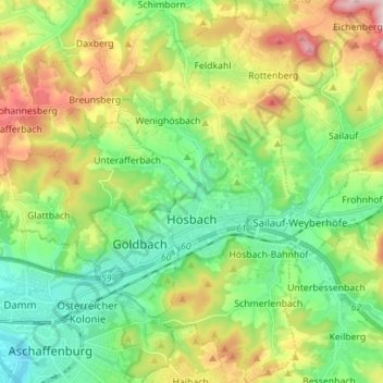
Nome: Mapa topográfico Hösbach, altitude, relevo.
Local: Hösbach, Landkreis Aschaffenburg, Bayern, 63768, Deutschland (49.96646 9.17373 50.05607 9.25265)
Altitude média: 223 m
Altitude mínima: 106 m
Altitude máxima: 439 m
Der topographisch höchste Punkt der Gemeinde ist der Gipfel des Rottenberges nordöstlich von Rottenberg mit 408 m ü. NHN (Lage)50.044679.24398, der niedrigste liegt an der Aschaff auf 134 m ü. NHN (Lage)49.998269.1955.
Outros mapas topográficos
Clique em um mapa para visualizar sua topografia, sua altitude e seu relevo.
Mainaschaff
Deutschland > Bayern > Landkreis Aschaffenburg
Mainaschaff, Landkreis Aschaffenburg, Bayern, 63814, Deutschland
Altitude média: 155 m