
Faça uma doação
Mapa topográfico Calape
Clique no mapa para exibir a altitude.
Faça uma doação
Calape
Most of the coastal area is a fairly level plain that gradually rises into rolling hills of coralline limestone. The highest point in Calape is Mount Candungao in the eastern portion of the town, with an elevation of 150 metres (500 ft) above sea level.
Faça uma doação
Sobre este mapa
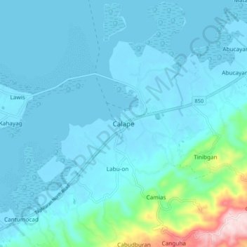
Nome: Mapa topográfico Calape, altitude, relevo.
Local: Calape, Bohol, Central Visayas, 6328, Philippines (9.85051 123.83187 9.93051 123.91187)
Altitude média: 46 m
Altitude mínima: -6 m
Altitude máxima: 416 m
Faça uma doação
Outros mapas topográficos
Clique em um mapa para visualizar sua topografia, sua altitude e seu relevo.
Rajah Sikatuna Protected Landscape
Philippines > Bohol > San Isidro
The Rajah Sikatuna park occupies the low mountain range in the south of Bohol island which corresponds geographically with the municipalities of Carmen, Sierra Bullones, Garcia Hernandez, Valencia, Dimiao, Bilar , Loboc and Batuan. It is characterized by rolling hills with remnants of natural forest on steep…
Altitude média: 349 m