
Obrigado por apoiar este site ❤️
Faça uma doação
Faça uma doação
Mapa topográfico Woking
Clique no mapa para exibir a altitude.
Obrigado por apoiar este site ❤️
Faça uma doação
Faça uma doação
Sobre este mapa
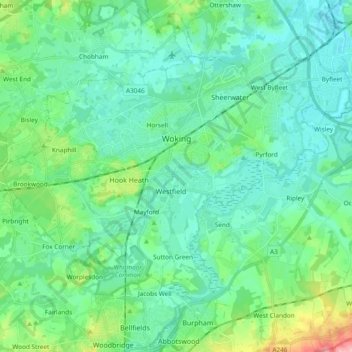
Nome: Mapa topográfico Woking, altitude, relevo.
Local: Woking, Surrey, England, United Kingdom (51.26549 -0.64998 51.34963 -0.46099)
Altitude média: 38 m
Altitude mínima: 12 m
Altitude máxima: 138 m
Obrigado por apoiar este site ❤️
Faça uma doação
Faça uma doação
Outros mapas topográficos
Clique em um mapa para visualizar sua topografia, sua altitude e seu relevo.
Redhill
United Kingdom > England > Surrey > Reigate and Banstead
To the north, the town joins with the village of Merstham, north of which there is a "wind gap" in the chalk hills of the North Downs, at an elevation of 120 metres (390 feet) above sea level, through which the A23 road heads in from London. Geologists have speculated that there may once have been a…
Altitude média: 107 m
Obrigado por apoiar este site ❤️
Faça uma doação
Faça uma doação
Obrigado por apoiar este site ❤️
Faça uma doação
Faça uma doação