
Obrigado por apoiar este site ❤️
Faça uma doação
Faça uma doação
Mapa topográfico Fairview
Clique no mapa para exibir a altitude.
Obrigado por apoiar este site ❤️
Faça uma doação
Faça uma doação
Fairview
The terrain is hilly to gently rolling, with elevations ranging from 200 feet near the Don Castro Regional Recreation Area (a park within the East Bay Regional Park District) to nearly 1,100 feet along Fairview Avenue.
Obrigado por apoiar este site ❤️
Faça uma doação
Faça uma doação
Sobre este mapa
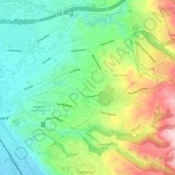
Nome: Mapa topográfico Fairview, altitude, relevo.
Local: Fairview, Alameda County, California, United States (37.65576 -122.07290 37.69570 -122.02398)
Altitude média: 123 m
Altitude mínima: 19 m
Altitude máxima: 305 m
Obrigado por apoiar este site ❤️
Faça uma doação
Faça uma doação