
Mapa topográfico Bululawang
Clique no mapa para exibir a altitude.
Sobre este mapa
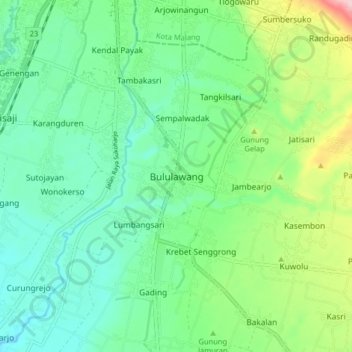
Nome: Mapa topográfico Bululawang, altitude, relevo.
Altitude média: 407 m
Altitude mínima: 349 m
Altitude máxima: 559 m
Outros mapas topográficos
Clique em um mapa para visualizar sua topografia, sua altitude e seu relevo.
Bromo Tengger Semeru National Park
Indonesia > East Java > Kabupaten Malang
Bromo Tengger Semeru National Park (Indonesian: Taman Nasional Bromo Tengger Semeru; abbreviated as TNBTS) is a national park located in East Java, Indonesia, to the east of Malang and Lumajang, to the south of Pasuruan and Probolinggo, and to the southeast of Surabaya, the capital of East Java. It is the only…
Altitude média: 1.343 m
Dsn. Blau Ds. Permanu Kec. Pakisaji, Malang
Indonesia > East Java > Kabupaten Malang
Altitude média: 478 m