
Mapa topográfico Cambria
Clique no mapa para exibir a altitude.
Cambria
Because lumber production, ranching activities and mercury mining increased in the area, the village adopted the more dignified name of Cambria. Locals seem to agree that the name was contributed by a local surveyor from Cambria County, Pennsylvania, because the local topography and flora reminded him of that place.
Sobre este mapa
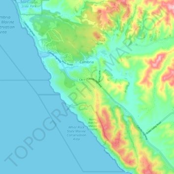
Nome: Mapa topográfico Cambria, altitude, relevo.
Local: Cambria, San Luis Obispo County, California, United States (35.50730 -121.12736 35.59544 -121.04896)
Altitude média: 58 m
Altitude mínima: 0 m
Altitude máxima: 257 m
Outros mapas topográficos
Clique em um mapa para visualizar sua topografia, sua altitude e seu relevo.