
Mapa topográfico Singabangsa
Clique no mapa para exibir a altitude.
Sobre este mapa
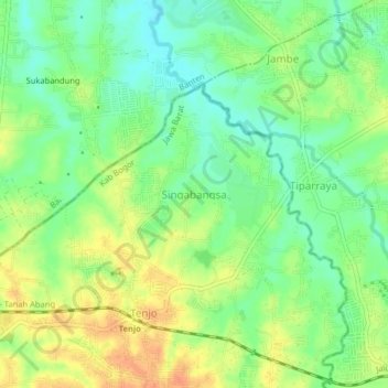
Nome: Mapa topográfico Singabangsa, altitude, relevo.
Local: Singabangsa, Bogor, West Java, Java, 15370, Indonesia (-6.33477 106.44838 -6.29477 106.48838)
Altitude média: 45 m
Altitude mínima: 27 m
Altitude máxima: 65 m
Outros mapas topográficos
Clique em um mapa para visualizar sua topografia, sua altitude e seu relevo.
Megamendung
Much of the district lies at an elevation of 500-600 metres, which moderates the temperature, and causing contrast to the heat of Greater Jakarta and other adjacent low-lying lands. Though much of the built-up area is not necessarily on rugged terrain, uneven ground is the most common terrain as it stands…
Altitude média: 738 m
Megamendung
Much of the district lies in an elevation of 500-600 metres, which moderates the temperature, and causing contrast to the heat of Greater Jakarta and other adjacent low-lying lands. Though much of the built-up area is not necessarily on rugged terrain, uneven ground is the most common terrain as it stands…
Altitude média: 742 m
Cisarua
Cisarua is a location and district in the Bogor Regency, located in the province of West Java, with a population of 127,096 in 2020. The district is known for its mild climate, tea fields, and extensive views, being located in a rather high altitude.
Altitude média: 1.310 m